In a couple of previous posts we have examined latitude and longitude in some detail, and explored in what format the numbers might be displayed on your handheld GPS unit. Here we will explore another commonly used coordinate system: UTM.
Latitude and longitude work well, but since they are all based upon circles, and because degrees are divided into groups of 60, the calculations required to work with them are unwieldy. It is frequently useful to have coordinates based upon plane rectangular geometry in our normal base 10 system. This can work well if the area in question is not too large, because then we can discount the curvature of the Earth. Over just a section of the Earth, the curve does not make a huge difference in error.
In order to do this, we must “flatten” the Earth to a plane, and when we do we can use the Cartesian coordinates that we all used in high school geometry class. It would be like flattening the peel of an orange. If you try to flatten the whole peel it makes a very irregular shape. But if you flatten a small piece it does fine. Then you can think of the x and y axes as east-west and north-south.

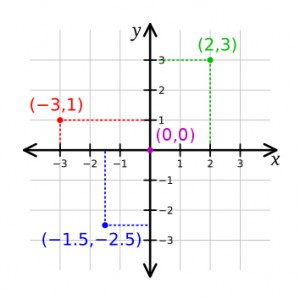
The familiar Cartesian coordinate system showing how points can be assigned a distance along two axes from the origin point.
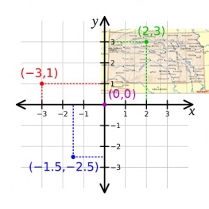
As you recall, every point on this plane can be described by two coordinates, one along each axis. And you can see in the illustration that some of the points have negative values with respect to the origin (point 0,0). However, we can control how we place the coordinate system, and with the origin point outside of our area of interest all the points can be positive (east, north)—in the upper right-hand quadrant.

The State of Kansas placed on the rectangular grid so that every point in the state will be positive with regard to the origin.
UTM coordinates, or Universal Transverse Mercator coordinates, are a rectangular plane system in metric units. Cartographers have taken swaths of each state and mathematically flattened them into a plane, assigned an origin southwest of each section, and laid out the resulting grid. Some of the smaller states are covered in a single swath, but the larger states must be broken into several zones so that the curvature of the Earth does not distort each map too much.
So, UTM coordinates have two components: their easting and northing values from the origin point in meters, and which state zone you are referring to. You can see a map of the zones here.
I have used UTM coordinates to good effect in my scientific work. When mapping a paleontological excavation, for example, we make all measurements in metric units. Since we are already measuring in metric units, every point in the dig site can easily be assigned its real-world UTM coordinate, instantly relating all points in the dig to any other point on the globe.
This means we can accurately and quickly plot the location of any fossil site, or even individual fossils, on a real-world map.
Related posts:
Recommended handheld GPS units
handheld GPS basics
Basic features in a handheld GPS
Geocaching
Mapping the Pratt Mammoth