Tag Archives: geologic formation

My National Geographic moment

“A photographer from National Geographic wants to talk to you.” These words, or words to those effect, met me as I came into the museum office one day back in 2001, and they definitely caught my attention.

It was 2001 and I was Assistant Director of the Sternberg Museum of Natural History. We had just reopened the museum in its new location in Hays, Kansas, a few years before in 1999. The museum had enjoyed some tremendous success at attracting visitors and media attention from across the state. And now someone from National Geographic wanted to talk to us? Wow. I returned Jonathan Blair’s call and began an unusual week of activity.

It turns out that the magazine was going to run a story on pterosaurs, the flying reptiles from the Mesozoic, and they hired Jonathan to get pictures to illustrate it. He had already traveled to some of the great museum collections for pterosaurs in Europe and the United States, but he wanted to visit Sternberg. The Sternberg’s collection of pterosaur material is about the third or fourth largest in the nation, and very significant.

The Sternberg Museum, on the campus of Fort Hays State University, was managed for many years by George F. Sternberg, famed fossil collector. He spent his free time out in the chalk, the Niobrara Formation of western Kansas, collecting the fish and swimming and flying reptiles that left their remains millions of years ago. Sternberg supplemented his salary at the museum by selling specimens to other museums, but if he collected something really nice it went into “his” museum. Over the years, the museum’s collection grew in size and quality.

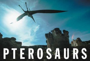
Besides our amazing collection of fossils, Jonathan had heard about our life-sized pterosaur models we had just installed in our walk-through Cretaceous exhibit. And he had a crazy idea—let’s take a life model of the beast and “fly” it over the very rocks where its remains can be found. He wanted to take one of our life-sized model and photograph it over the chalk beds.

Well, I can bend over backwards for National Geographic, but taking one of our brand new models down from the ceiling, which had not been easy to install in the first place, and which since had walls built up around them, and truck them 70 miles to hang from a crane in the chalk sounded a bit risky to me.

But I did offer to help in any way we could, so I did the next best thing—I found him another pterosaur model.

Over the next several days we made plans and preparations for the big event. We needed to get the model that I was able to find shipped to the museum. It had been kept in storage and was a little beaten up, but the company that supplied it sent a staff member to clean, fix it, and touch up the paint for its big moment. The model, being life-sized, had a twenty foot wing span, flimsy neck with a large head at the end, and feet that stuck out the back, giving the whole thing a cross shape, making it too long in any direction. Not exactly the easiest thing to get into a truck and ship!

We scouted a location for the big photo shoot. I took Jonathan to the Castle Rock area, a well-known outcropping of the chalk that has easy access and grand vistas. We needed to secure special permission as we were going to bring in a crane and another truck to transport the pterosaur model.

We needed to arrange for a crane to make the 70 mile one-way trip from Hays to the chalk beds. On this, and on so many other occasions, I marveled at the “can do” spirit of western Kansas people. You want something done just ask a former farm kid. While he might look at you funny, he will get it done.

In between all this activity, I remember some spectacular meals shared with Jonathan, listening to his many adventures from around the world while taking photographs. He also shot pictures around the museum, and he took a couple of photos of me that I have cherished ever since.
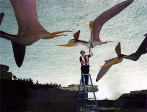
Greg dusts the life-sized models of Pteranodon sternbergii in the Sternberg Museum of Natural History

Greg dusts the life-sized models of Pteranodon sternbergii at the Sternberg Museum of Natural History. Photograph by Jonathan Blair.

The big day arrived and all was going well. The weather cooperated, the truck was loaded with its ungainly cargo, and the crane made it to the site. We had also brought along a number of crew members to help hold the model. We wanted to lift it into the air for the photograph, but if you know anything about western Kansas, you know it is windy. I was not sure what would happen when you lifted such a thing into the gusty winds, and how hard it might be to control. The only control we had were guy-wires coming down from the wing tips to hold it against unruly behavior.

With trepidation we gave the signal to the crane operator to lift, and the hundred pound model took to the air. And in the end, the wind was no issue—the model, like the animal it represented, was built for the air. It found a comfortable equilibrium and settled into the wind easily. Jonathan snapped his pictures, and just like that we had what he had come after.

Life-sized model of a pterosaur, an ancient flying reptile, soars onces again over western Kansas

Life-sized model of a pterosaur, an ancient flying reptile, soars once again over western Kansas

We took more photos at a few other locations, all of which could have made fantastic desktop images, but he knew he was done. We packed up and came home, and all those days preparation resulted in the lead image for the story. It was all Jonathan’s photo and idea, and I enjoyed the part I played in making it happen—one of the perks for working at a museum.

See the National Geographic story.

Jonathan Blair’s web page

Related Posts
Geologic Formations
Spending time in Purgatoire

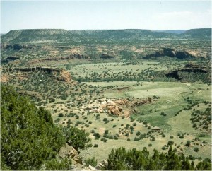
One of the many places that I have been fortunate to spend time in is Purgatoire. Perhaps not the same thing you are thinking, but I am referring to the Purgatoire River Canyon in southeastern Colorado. Located south of La Junta, this area is an often-overlooked gem. The scenic vistas could be used for your desktop wallpaper!

Purgatoire River Canyon in southeastern Colorado

Purgatoire River Canyon in southeastern Colorado

The many names applied to the region can be confusing. The Purgatoire River has cut a dramatic canyon in this part of the plains, and with the Rocky Mountain Front Range far to the west, it can be almost startling to come upon the deep canyon in an otherwise rolling plains landscape. Anglo settlers bastardized the name of the river, and instead of the eloquent Purgatoire, ended up calling the area Picket Wire, so both names alternately apply.

The area is managed predominately by two federal agencies, the United States Department of Agriculture’s Forest Service and the Department of Defense through the Army. The military uses their lands for maneuver practice, as I understand it, tanks and other mechanized equipment. Some years ago the Army carved off some of their land and gave it to the Forest Service to manage as part of the Comanche National Grassland. The Forest Service land is used for recreation and also the preservation of significant historic and prehistoric resources.

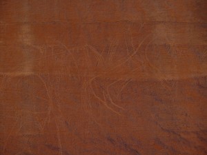
Petroglyph of human and horse figures

Petroglyph of human and horse figures

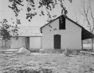
Rourke Ranch house in the Purgatoire Canyon

Rourke Ranch house in the Purgatoire Canyon

The historic resources include Native American petroglyphs and other archeological sites, early Spanish homestead sites and churches, early American homesteads. The prehistoric resources include dinosaurs and other prehistoric animals, both body fossils and trace fossils. I was very fortunate to have been involved in the documentation of some of the first dinosaur fossils from the region (Schumacher and Liggett 2004).

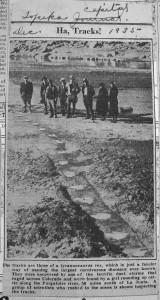
Dinosaur trace fossils, in particular dinosaur tracks, are well preserved in one section of the Morrison Formation in the bottom of the canyon. These tracks were discovered in 1935 by a young girl as can be seen in this newspaper clipping from the Topeka Capital Journal. However, the tracks are most definitely not those of a Tyrannosaurus rex (mentioned in the clipping) as that beast did not stalk the Earth for at least 90 million years after the track-makers walked here. This track site is the largest continuous track site of dinosaurs known from North America, and contains over 1,400 prints.

Newspaper clipping announcing the discovery of the Purgatoire track site

Newspaper clipping announcing the discovery of the Purgatoire track site

However, because of the remoteness of the site, scientists turned their attention to other dinosaur tracks found in Texas, and the Colorado tracks were essentially forgotten for many decades. However, a newer generation of scientists have re-examined the track site. Of interest is the fact that the site shows five parallel sauropod tracks, suggesting that at least in this case, the animals walked along together spread out, not walking in a line (Lockley 1991).

There are actually several track layers in the rocks. Also preserved are several three-toed theropod, or meat-eating dinosaur. While it is difficult to exactly match the track to the species of dinosaur that made them, the large sauropod tracks were made by an animal like Apatosaurus (Brontosaurus of old) and the meat-eating tracks are similar to what an Allosaurus would make.

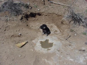
A well-preserved theropod dinosaur track in the Purgatoire Canyon

A well-preserved theropod dinosaur track in the Purgatoire Canyon

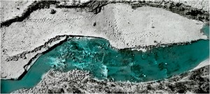
View of the Purgatoire River track site using low altitude photography

View of the Purgatoire River track site using low altitude photography

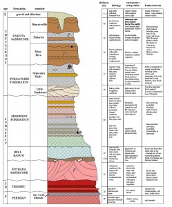
In addition to the tracks, the canyon is also now yielding body fossils of dinosaurs. It is really no surprise since the Morrison Formation is extensively exposed along the river canyons. The Morrison is the name given to a wide-spread formation that is the most prolific producer of Jurassic dinosaurs in North America. The formation outcrops in North Dakota, South Dakota, Montana, Wyoming, Colorado, Oklahoma, Texas, New Mexico, Arizona, Utah, and Idaho. Every Jurassic dinosaur you have ever heard of comes from the Morrison; animals such as Allosaurus, Apatosaurus, Diplodocus, Stegosaurus, and Camarasaurus all come from this formation. (See Formations for information about what that means.)

Stratigraphic section of the Purgatoire River Canyon showing the geologic formations that outcrop

Stratigraphic section of the Purgatoire River Canyon showing the geologic formations that outcrop

Given the Purgatoire River’s remoteness, and the fact that it was controlled for many years by the Army, few people were able to explore the region until more recent decades. Thus, now it is one of the last areas of the Morrison Formation exposures to be explored. And it is proving to be as rich as expected.

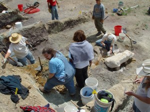
Over the last decade, the Forest Service has been conducting Passport in Time (PIT) programs in the canyons, looking for new dinosaur sites, and excavating sites. Many people, scientists, graduate students, and the lay public have enjoyed excavating dinosaurs in this beautiful and remote canyon. And several significant specimens have come out of the area. The Forest Service has partnered with many museums from the region to study this treasure-trove and to allow people to enjoy this amazing region.

Volunteers excavate dinosaur fossils from the Woody site

Volunteers excavate dinosaur fossils from the Woody site

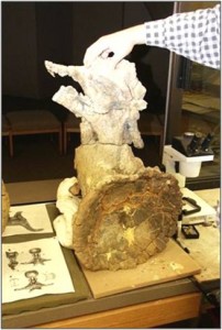
Dinosaur vertebra from the Woody Site being prepared at the Sternberg Museum of Natural History

Dinosaur vertebra from the Woody Site being prepared at the Sternberg Museum of Natural History

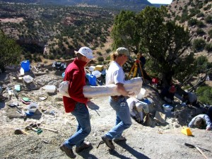
Plastered dinosaur bone being carried out of the LC Site

Plastered dinosaur bone being carried out of the LC Site

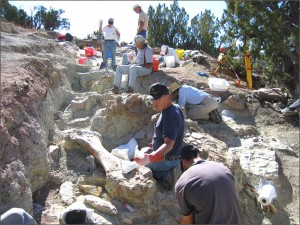
Volunteers excavate dinosaur bones from the Morrison Formation at the LC site

Volunteers excavate dinosaur bones from the Morrison Formation at the LC site

The Forest Service offers tours of the canyon and track site. If you are interested contact the Forest Service Office at 1420 East 3rd, La Junta, CO 81050, 719-384-2181. If you plan to visit the area on your own, be aware of a couple of things. You cannot drive into the canyon without prior authorization. You can hike in on your own, but it is several miles in and out, and the summer temperatures can be brutal, so bring plenty of water and plan accordingly.

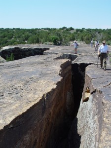
A large section of Dakota Formation slumping away from the main block provides a dramatic hiking experience

A large section of Dakota Formation slumping away from the main block provides a dramatic hiking experience

Lockley, M. G. 1991. Tracking Dinosaurs: A New Look at an Ancient World. Cambridge University Press, New York.

Schumacher, B. A., and G. A. Liggett. 2004. The dinosaurs of Picketwire Canyonlands, a glimpse into the Morrison Basin of southeastern Colorado. Journal of Vertebrate Paleontology 24(Supplement to 3):110A. (Poster page 1 and page 2).

Many other dinosaur facts can be found here at Boneblogger. Just search or select the category.

Formations

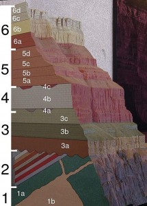
The crust of the Earth is composed of a complex mix of rock types formed in specific depositional environments. Most of your everyday experience occurs in erosional environments, places where the surface of the Earth is being eroded away by physical or chemical processes. Rocks underfoot are being broken up then transported as sediments to other areas. The Grand Canyon is a good example of a river cutting through the layers of rock, exposing those layers, and transporting the rock away—piece by piece.

A cross section model of the Grand Canyon showing the rock layers and how they are broken into recognized formations.

A cross section model of the Grand Canyon showing the rock layers and how they are broken into recognized formations.

Where is that material going? It is transported to places where it is deposited, depositional environments, where the sediments accumulate. Given enough time and protection from further weathering, those newly deposited sediments can become the sedimentary rocks of the future. The deposition of sediment occurs in a wide variety of environments such as in oceans, rivers, ponds and the like.

If we look at the rocks on the surface of the Earth today, we can see differences in their color, texture, composition, and so on. We see layering as one rock type gives way to another. Geologists map these layers to trace out the history of the Earth, as each change in rock type represents a change in the environment that created it. So each outcropping of rock represents a time machine of sorts, transporting us back to the primeval environment of that spot.

A geologic formation is a formal unit, technically called a lithostratographic unit. That fancy word simply means that rocks are grouped by similar lithology, or rock type. For example, during the Late Cretaceous the last inland sea across the mid-continent of North America (a specific environment) deposited thick accumulations of chalk and shale. Today, we can lump specific sections of that collection of rock (lithology) into a single formation and call it the Niobrara Formation.

Each formation is described and named in a specific, formal way. There are rules that geologists should follow in designating specific formations (North American Commission on Stratigraphic Nomenclature, 2005). For example, each formation should have a type section designed. This type section is not unlike a type specimen mentioned in another post: it represents the standard for that formation to help others understand how it is unique.

In future posts we will explore more aspects of formations.

NORTH AMERICAN COMMISSION ON STRATIGRAPHIC NOMENCLATURE. 2005. North American Stratigraphic Code. American Association of Petroleum Geologists Bulletin, 89(11):1547-1591.

Related Post

Spending time in Purgatoire