Author Archives: Greg

Giant Short-Faced Bear Reexamined

As the old saying goes, looks can be deceiving. That is the theme of a new paper on the Giant Short-Faced Bear (GSFB), Arctodus simus, recently published in the Journal of Vertebrate Paleontology (Figueirido et al., 2010).

We have explored this beast in other posts (see below), and will no doubt do so in the future, as it is one of my favorite animals because of the fascinating paradoxes that it presents. Bears as a group often do not do what we think they should do!

The GSFB is the largest mammalian carnivore known, fossil or recent. First discovered in Northern California and described by Cope in 1879, remains of this species have since been recognized from Alaska to Mexico, and from the west coast east to Pennsylvania in North America. It lived from about 1 million years to about 10,000 years ago. It is likely that they became extinct as an ultimate effect of climate change at the end of the Ice Age.

Kurten (1967) was one of the first to look at the GSFB in much detail, and he made a number of observations  that have come to define this bear: shortened face like a cat, and extremely long limbs compared to body length. Kurten argued that those adaptations show a hypercarnivore, a cat-like giant predatory bear, with long runner’s legs and a bite-style like the large cats.

There is something very appealing in this picture: a huge cat-like bear running down prey and dominating the Ice Age landscape. Alas, science cannot be based on drama or romantic notions, and this image of the GSFB gets reexamined from time to time, with other authors coming to different conclusions. Some have pointed out the ambiguity of the limb proportions, or compared the GSFB to its closest living relative, the South American spectacled bear, and concluded that it was primarily omnivorous with a diet rich in plants (Emslie and Czaplewski, 1985).

The question of what the GSFBs were eating, at least, seemed to have been dramatically concluded in a couple of papers during the mid-1990s (Bocherens et al., 1995; Matheus, 1995). Those authors explored the carbon and nitrogen stable isotopes preserved in skeletal material. You are what you eat as differing amounts of these elements are deposited in body tissues depending on their dietary sources, and the isotope data clearly show that the GSFB were eating mostly meat in their diet.

In the most recent paper, Figueirido and colleagues also re-examine Kurten’s cat-like interpretations of the GSFB. For example, they challenge the very notion that the GSFB was short-faced at all. While a casual observation of the skull seems to “bear” that out, they compared the skull and face length with other bears, and it seems that what makes the skull of the GSFB look short-faced is really the depth of the snout and the height of the skull overall, creating an illusion of short-facedness.

Snout lengths relative to skull length in living bears and in the GSFB.

They also ran a number of statistical analyses on the dimensions of the skulls of bears with other carnivores to see if differences in feeding behavior might be teased out this way. Feeding strategy, such as cat-like hypercarnivory or hyena-like bone-crushing, might be visible in the skull proportions. They concluded that the GSFB had a skull shape not like that of a cat, but more similar to modern brown bears (Ursus arctos). Brown bears are omnivorous and will certainly eat meat, but also have a significant amount of plant matter in their diet. So, those authors suggest the skull shape does not support a hypercarnivorous behavior.

Figueirido et al. also examined the claim that the GSFB had extremely long legs. They compared total limb length to overall body weight among modern bears and the GSFB. Their results suggest that the limb length is just what it should be for a bear of the overall size of the GSFB, and not especially long when compared to other bears.

Nothing in science is sacred and I applaud Figueirido et al. for critically looking at past interpretations. However, the answers to our questions continue to elude us. If they are right that the GSFB was not especially short-faced, and that the limbs were not especially long, and the skull was not especially cat-like, none of that really nails down the behavior of this giant species, as they point out. And bears in particular have a tremendous range of feeding adaptations and behaviors that do not fit the mold.

For example, modern bear behavior goes from one extreme represented by the polar bear, which lives on the arctic sea ice and eats almost nothing but seals, to the giant panda living in Asian forests and eats almost nothing but bamboo (but they too will eat meat if given the chance). And between those extremes is a lot of variation. There is really no reason to think that the GSFB was not also variable in its diet and behavior to some degree. But the isotope evidence is hard to argue with at the moment: they seem to have eaten a lot of meat.

The question remains though, how did they get their meat? Did they chase down their prey in long pursuits, or ambush them from short range, or act as the neighborhood bully and chase smaller carnivores from their kills? We don’t yet know but we will keep looking.

Related Posts:
GSFB, a North California Original
Denning Behavior in the GSFB
How Big was the GSFB?
Polar Bear Populations

BOCHERENS, H., S. D. EMSLIE, D. BILLIOU, AND A. MARIOTTI. 1995. Stable isotopes (C13, N15) and paleodiet of the giant short-faced bear (Arctodus simus). Comptes Rendus de l’Acadƒemie des Sciences Paris, 320, serie IIa:779-784.

EMSLIE, S. D., AND N. J. CZAPLEWSKI. 1985. A new record of giant short-faced bear, Arctodus simus, from western North America with a re-evaluation of its paleobiology. Contributions in Science, 371:1-12.

FIGUEIRIDO, B., J. A. PEREZ-CLAROS, V. TORREGROSA, A. MARTIN-SERRA, AND P. PALMQVIST. 2010. Demythologizing Arctodus simus, the ‘short-faced’ long-legged and predaceous bear that never was. Journal of Vertebrate Paleontology, 30(1):262-275.

KURTEN, B. 1967. Pleistocene bears of North America; 2. genus Arctodus, short-faced bears. Acta Zoologica Fennica, 117:1-60.

MATHEUS, P. E. 1995. Diet and co-ecology of Pleistocene short-faced bears and brown bears in eastern Beringia. Quaternary Research, 44:447-453.
UTM

In a couple of previous posts we have examined latitude and longitude in some detail, and explored in what format the numbers might be displayed on your handheld GPS unit. Here we will explore another commonly used coordinate system: UTM.

Latitude and longitude work well, but since they are all based upon circles, and because degrees are divided into groups of 60, the calculations required to work with them are unwieldy. It is frequently useful to have coordinates based upon plane rectangular geometry in our normal base 10 system. This can work well if the area in question is not too large, because then we can discount the curvature of the Earth. Over just a section of the Earth, the curve does not make a huge difference in error.

In order to do this, we must “flatten” the Earth to a plane, and when we do we can use the Cartesian coordinates that we all used in high school geometry class. It would be like flattening the peel of an orange. If you try to flatten the whole peel it makes a very irregular shape. But if you flatten a small piece it does fine. Then you can think of the x and y axes as east-west and north-south.

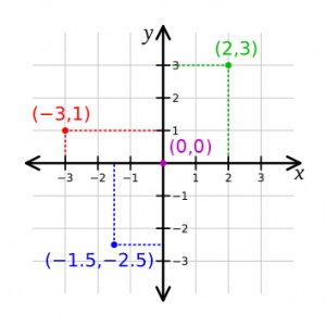
Cartesian coordinate system illustrated

The familiar Cartesian coordinate system showing how points can be assigned a distance along two axes from the origin point.

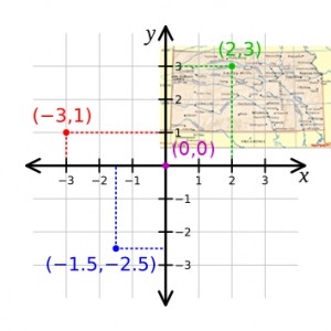
As you recall, every point on this plane can be described by two coordinates, one along each axis. And you can see in the  illustration that some of the points have negative values with respect to the origin (point 0,0). However, we can control how we place the coordinate system, and with the origin point outside of our area of interest all the points can be positive (east, north)—in the upper right-hand quadrant.

State of Kansas laid on top of a Cartesian coordinate form

The State of Kansas placed on the rectangular grid so that every point in the state will be positive with regard to the origin.

UTM coordinates, or Universal Transverse Mercator coordinates, are a rectangular plane system in metric units. Cartographers have taken swaths of each state and mathematically flattened them into a plane, assigned an origin southwest of each section, and laid out the resulting grid. Some of the smaller states are covered in a single swath, but the larger states must be broken into several zones so that the curvature of the Earth does not distort each map too much.

So, UTM coordinates have two components: their easting and northing values from the origin point in meters, and which state zone you are referring to. You can see a map of the zones here.

I have used UTM coordinates to good effect in my scientific work. When mapping a paleontological excavation, for example, we make all measurements in metric units. Since we are already measuring in metric units, every point in the dig site can easily be assigned its real-world UTM coordinate, instantly relating all points in the dig to any other point on the globe.

This means we can accurately and quickly plot the location of any fossil site, or even individual fossils, on a real-world map.

Related posts:
Recommended handheld GPS units
handheld GPS basics
Basic features in a handheld GPS
Geocaching

Mapping the Pratt Mammoth

How To Have A Smooth Flowing Australian Holiday

Guest Post

When you are looking to have the most wonderful holiday experience then you should make plans to visit the Gold Coast region of Australia. No matter where you are traveling from to visit there are many reasons that you will find the Gold Coast as a wonderful region. There are three main factors to having the best possible experience while visiting the Gold Coast, and they will be outlined in the latter part of this article.

Proper Time Management- The Gold Coast makes up a captivating region, beautiful and constructed with numerous activities for you to savor. Having the best imaginable holiday experience means balancing your inactive days by the beach with days filled up with activities. It\’s a challenging counterbalance, but the one and only that will contribute to the most salutary and fantastic experience to your holiday. Make sure that the day you arrive and the one right before you set out for home, are slothful beach days. Attempting to accomplish too many activities is a large mistake when visiting this region. Flip-flopping activity days with beach days and will bring about the best of both worlds.

Plan In Advance- Try to lay out the important aspects of your travel well in advance. Use the web to gain the information you need and to make reservations. The more you lay out in advance, the less you will leave to chance, and this will make for a most successful holiday.

Knowing Right From Wrong In The Region- When ever you are traveling to an unfamiliar location it is important that you make your self aware of all the rules, traffic laws, and even beach rules of the area. It is also a wise idea to learn about the different terminology of things as well as the language that is spoken. By learning all this before you leave on your trip you will make for a much smoother holiday experience.

Whether you are looking for an adventurous holiday or a lazy, laid back beach holiday, the Gold Coast will not disappoint!

When you are looking for gold coast hotels the best place to log onto is www.goldcoastinformation.com.au. They have all the information that you need to plan a fabulous vacation.

Latitude and longitude 2

In the first discussion of latitude and longitude, we investigated how the latitude-longitude grid was established. In this post we will look at how that relates to the display on your handheld GPS unit.

If I stand outside with my GPS and direct the unit to display my position, it may do so in a couple of different ways. First, it might show my position on a map background, pinpointing my location with regard to other features such as streets, buildings, or landforms. This shows me my location as if I were walking around on the map.

I might want to know my latitude and longitude coordinates. Perhaps I want to record them so I can return to this spot in the future. (You can understand why a “bone digger” would want that!) In most handheld GPS units you can save your location as a waypoint. (See my review of the best GPS units.)

A really useful thing to be aware of about has to do with the format of latitude and longitude number displays. These numbers can be expressed in several ways, and you must know which format the numbers are in or risk making errors. After GPS units first came out, I used one to locate some fossil sites where I collected. I happily recorded the coordinates for the fossils I picked up, and dutifully wrote them in my field book. Only later did I realize that I was not perfectly clear which form the coordinates were in, making the records almost useless!

Most handheld GPS units allow you to display the coordinates in several formats. You could show the form degrees-minutes-seconds, sometimes denoted as DMS. This might look something like 38°53’22.49″N, 99°17’58.73″W. Latitude is given as degrees north or south from the equator, and longitude is given as degrees east or west from the prime meridian.

But we could also give these same numbers in another format which would look like: 38° 53.375’N, 99° 17.979’W. This format is in the form of degrees, minutes, and decimal minutes, or DMM.

Finally, we could show these coordinates as full decimal degrees (DDD) and it would look like: 38.889583°, -99.299650°. Note that in this form, the positive or negative form of the number is important as that gives the direction. Positive latitude numbers are north, and negative longitude numbers are west.

Notice that these forms are all equal: 1° 30′ 30″ (DMS); 1° 30.5′ (DMM); 1.5083° (DDD). And you can see if you just wrote down numbers on a page, and were not very clear about which form the numbers were in, you could be very far off the mark in terms of location.

There is another common coordinate form called UTM which we will examine in another post. Bonus points to anyone who can tell me what is at the coordinates used in this post.

Latitude & Longitude

Thought question: when you are standing at the North Pole, which direction are you looking?

A topic that I think people find a bit confusing is the coordinate systems commonly used in their handheld GPS units. The handheld GPS can tell you your exact location, and this is because cartographers have partitioned the surface of the Earth so that one point can be located with regard to any other point. However, over time they have developed a variety of different coordinate systems to meet various needs.

The most commonly used coordinate system is probably the latitude and longitude grid. This system is based on two 360 degree circles that are envisioned to circle the planet. The first great circle spans the planet from “head to toe,” or along the axis of rotation. The second great circle goes around the “waist” of the planet, at right angles to the axis of rotation, and along the planet’s midline. We call this great circle the equator.

You no doubt learned that a circle can be divided into 360 degrees. The circle of the equator can likewise be divided, but where should we start? The line projected from the North Pole through Greenwich, England, through the equator to the South Pole is the prime meridian. Here, “prime” means “first” or “initial.” The point where it crosses the equator is the starting point for dividing the equatorial circle.

Why Greenwich, England, you ask? This standard was really only recently set, in 1884, when delegates from 25 nations met in Washington, D.C. for the International Meridian Conference. They adopted the meridian passing through the Transit Instrument at the Greenwich Observatory as the “prime” one. You have to start somewhere!

From the prime meridian, we can measure around the circle of the equator east and west up to 180 degrees, covering the full circle. This establishes the lines of longitude (running from the pole to pole) and defines the directions “east” and “west.”

We can divide the prime meridian into its 360 degrees also, and we find it useful to start at the equator and count 180 degrees from pole to pole. So, you can go from zero to 90 degrees in both directions, north and south, and this establishes lines of latitude, and defines “north” and “south.”

Notice that lines of latitude do not converge on a spot—they remain parallel to each other on the globe. However, lines of longitude do converge, at the poles. What this means is that the distance on the ground remains the same between degrees of latitude. But the degrees of longitude get closer together as you approach the poles. In other words, one degree of longitude at the equator is a longer physical distance on the ground than one degree of longitude farther to the north, say in Greenland. This is just an interesting complication of living on a sphere.

And it is because of that complication that I know exactly which direction you are looking when you are standing on the North Pole—no matter how you turn your body, you are by definition looking south. At 90 degrees north there is so other way to go but down (in latitude, that is).

Related posts:
Handheld GPS basics
Basic features in a handheld GPS unit

Recommended handheld GPS units
Latitude and Longitude 2
UTM